About Michael Howser

Michael serves as the Director of the Connecticut State Data Center and the Director of the UConn Library at Hartford Public Library.

Open Data in Action – October 26, 2017 at Hartford Public Library

Open Data In Action brings together a wide range of researchers to showcase how their work has benefited from openly and freely accessible data. Presenters from the public, private, and academic sectors will discuss how open data, ranging from historical documents to statistical analyses, is being used to create projects, change policies, or conduct research and highlight the importance open data has on shaping the world around us.

This event will feature a number of open data focused researchers and open data providers and is open to the public.
When: Thursday, October 26, 11:00am-2:00pm

Where: Hartford Public Library, Atrium 500 Main Street, Hartford, CT

Who can participate: Free and open to the public

Cost: Free
Opening Remarks:

Tyler Kleykamp, Chief Data Officer, State of Connecticut


Presenters:

Rachel Leventhal-Weiner, CT Data Collaborative, CT Data Academy

Jennifer Snow, UConn Library, Puerto Rico Citizenship Archives: Government Documents as Open Data

Tina Panik, Avon Public Library, World War II Newsletters from the CTDA

Rebecca Sterns, Korey Stringer Institute, Athlete Sudden Death Registry

Andrew Wolf, UConn Digital Media & Design, Omeka Everywhere

Steve Batt, UConn Library /Connecticut State Data Center, Tableau Public and CT Census Data

Anna Lindemann/Graham Stinnett, UConn/DM&D, & Archives, Teaching Motion
Graphics with Human Rights Archives

Thomas Long, UConn Nursing, Dolan Collection Nursing History Blog

Jason Cory Brunson, UConn Health Center, Modeling Incidence and Severity of Disease using Administrative Healthcare Data

Brett Flodine, GIS Project Leader, City of Hartford Open Data

Stephen Busemeyer, The Hartford Courant, Journalism and the Freedom of Information

Open_Data_Sponsors


Connecticut’s Towns Experiencing a Demographic Shift from 2015 to 2040, Connecticut State Data Center Reports

August 31, 2017 – Towns in Connecticut are projected to slowly gain population as a total, according to the 2015 to 2040 population projections for all 169 towns in the state of Connecticut, released today by the Connecticut State Data Center.

2015_2040_town_projected_growth

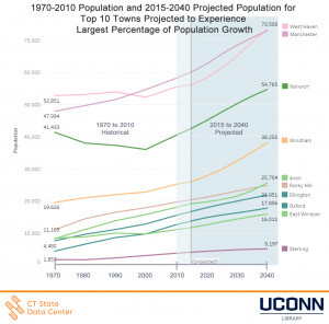
1970-2010 Population and 2015-2040 Projected Population for Top 10 Towns Projected to Experience Largest Percentage of Population Growth

The new projections show that multiple towns are approaching a demographic shift due to an aging population, a near net zero overall migration rate, and a relatively low, but stable, birth rate.  Windham, East Windsor, Avon, Oxford, Ellington, Sterling, Norwich, West Haven, Rocky Hill, and Manchester are expected to experience the largest percentage of increase in overall population projected from 2015 to 2040.

2015_2040_town_projected_decline

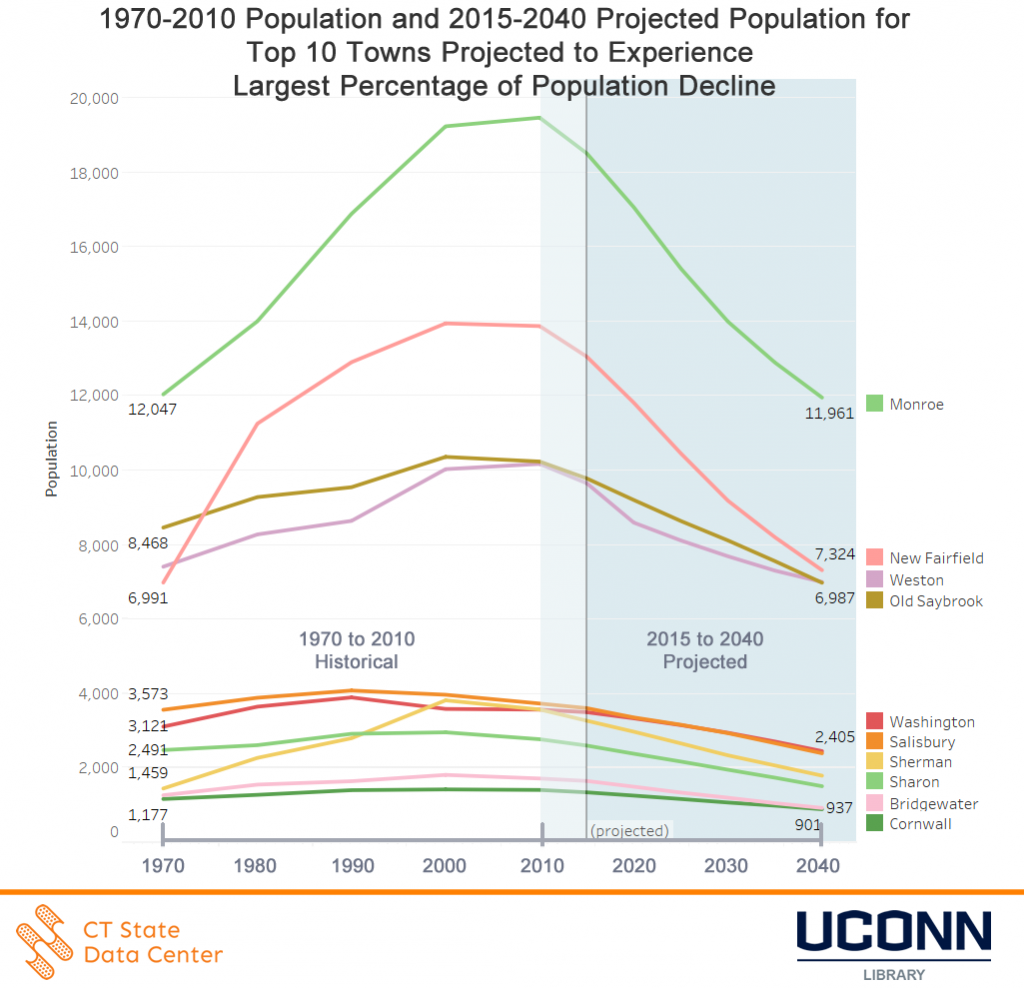
1970-2010 Population and 2015-2040 Projected Population for Top 10 Towns Projected to Experience Largest Percentage of Population Decline

The towns of Sherman, New Fairfield, Bridgewater, Sharon, Monroe, Cornwall, Salisbury, Old Saybrook, Washington, and Weston are projected to experience the largest percentage of decline in the overall population from 2015 to 2040.

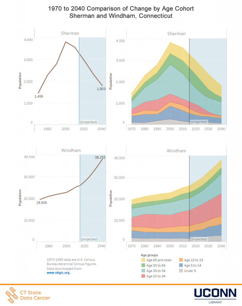
The changing demographics by age cohort for towns in Connecticut provides a more complete picture of the overall trends within towns over time.  The Connecticut State Data Center has released an interactive data dashboard to accompany the release which enables users to view demographic changes town by town with data from 1970 to 2040.  When reviewing the age cohort data, long-term trends in demographics shifts within towns, and more broadly across the state when comparing multiple towns, indicate which towns are experiencing stable or declining births by examining the under 5 age cohort, as well as visually presenting the demographic shift between age cohorts as individuals age 55 to 64 age into the 65+ age cohort.


The comparison between are largest percentage of population gain (Windham) versus our largest percentage of population decline (Sherman) highlights the shifts in age cohorts within these towns.

1970_2040_age_cohort_change_Sherman_Windham

1970 to 2040 Comparison of Change by Age Cohort for Sherman and Windham, Connecticut


Connecticut’s eight most populous towns will see a growing or stable population based on the projections from 2015 to 2040, following an overall trend for several of these towns since 2000.

Overview, Connecticut will grow slowly in population from 2015 to 2040. The projected populations for each town can differ over time based on factors not included within the projections model, and thus these population projections are reviewed annually by the Connecticut State Data Center and compared to the most recent data to adjust projections if data reflects changes in the projected trend for a town. For more details on the data release and how to view and access data, visit the Connecticut State Data Center 2015 to 2040 Town Population Projections site.

Connecticut State Data Center Embargo Release of 2015-2040 Population Projections for the State of Connecticut Towns

August 15, 2017 – The Connecticut State Data Center will release the 2017 edition of the state of Connecticut Town Population Projections for 2015 to 2040 on August, 31, 2017.  This release will include population projections by five year age cohorts and sex for each of the 169 towns in the State of Connecticut.  This release only includes town population projection with other geographies for Connecticut to be released in upcoming releases.  Prior to the public release of the town population projections for 2015 to 2040, the Connecticut State Data Center will offer embargo access to the media and to Connecticut focused data organizations in advance of the public release.

When: Tuesday, August 29, 2017 at 10 a.m. EDT to Thursday August 31, 2017 at 12:01 a.m. EDT.

Where: Connecticut State Data Center embargo site.

Interview requests: Embargo subscribers may interview Connecticut State Data Center staff during the embargo period.  To request an interview, email ctsdc@uconn.edu.

Obtain media and Connecticut focused data organizations embargo access: Visit the Connecticut State Data Center’s embargo website for access.

Embargoed summary documents, press release templates, data visualizations, and raw data may not be released to the public by any means (including print, broadcast, Internet, podcast, social media, blogs, or in any other form) prior to public release.  The public release will be at 12:01 a.m. EDT, Thursday August 31, 2017.

For more details on the embargo and how to request embargo access, visit the Connecticut State Data Center Embargo site.

Connecticut’s Population is Expected to Grow Slowly, Connecticut State Data Center Reports

For Immediate Release: Monday July 31, 2017
(Revised September 19, 2017)

Connecticut’s Population is Expected to Grow Slowly, Connecticut State Data  Center Reports


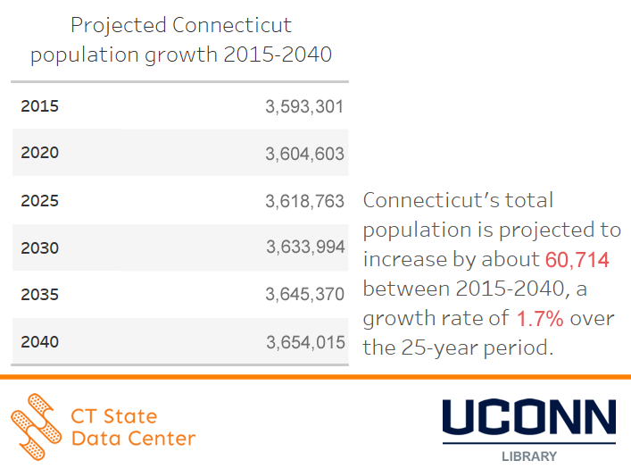
July 31, 2017 –  The state of Connecticut is expected to add about 60,700 residents from 2015 to 2040, according to the 2015 to 20140 population projections for the state of Connecticut, released today by the Connecticut State Data Center.


The new projections, based on the age characteristics of the states population along with recent birth, death, and migration rates, indicate that the states resident population is expected to grow from about 3.59 million in 2015 to approximately 3.65 million in 2040, a 1.7% growth rate over the 25-year period.
projected_Connecticut_population_growth_2015_2040_table

Figure 1: 2015 to 2040 Population Projections for the State of Connecticut

The slow projected growth mirrors that of states in the region, with most states in New England predicting small gains in population, or even negative growth, in the foreseeable future.


From 2010 to 2030, Connecticut is projected to gain 1.7%, Maine is projected to lose 0.5%, Massachusetts is projected to gain 10.4%, New Hampshire is projected to gain 6.6%, New York is projected to gain 2.2%, Rhode Island is projected to gain 1.7%, and Vermont is projected to gain 7.1% in population, according to projections produced by each of the respective states.

regional_population_changes_for_New_York_and_New-England_2010_2030

Figure 2: Projected Population Change for New York and New England, 2010 – 2030*


A main factor driving low projected growth are regional trends in fertility rates, the number of births per 1,000 women of childbearing age. New England states fertility rates trailed those of all other states in 2015, according to the latest data from U.S. Health and Human Services. Connecticut’s fertility rate of 52.5 was the 5th lowest in the country, slightly greater than rates in Rhode Island, Massachusetts, New Hampshire and Vermont, which ranked last.


As the baby boomer generation ages, a generational shift is projected to occur in Connecticut as the Millennials (individuals born 1981-2000) remain a nearly stable population in Connecticut while the population born after 2000 is projected to continue to rise from 637,000+ in 2015 to a projected 1.8 million by 2040.

projected_change_for_generations_born_after_1945_ct_projections_2015_2040

Figure 3: Projected Change for Generations Born after 1945


“Land of steady habits” summarizes the overall recent trends of birth, mortality, and migration rates, trends which are held constant in the projection models. Migration – both domestic and international – also contributes to changes in Connecticut’s projected population.  With recent years seeing Connecticut’s population change nearing a net zero, when compared to birth, mortality, and international migration, it is important to look at the entire picture of data to see that Connecticut continues to experience growth.

With a projected 1.7% growth rate projected from 2015 to 2040, this rate can be influenced by a number of factors ranging from changes in domestic and international policy related to migration, to changes in fertility rates.


Figure 3: Projected Change in Population for Generations Born After 1945

The population projections included in this release are based solely on demographic trends, and do not attempt to predict or account for future changes in economic, employment, or housing factors in the state.
For more details on the data release and how to view and access data, visit the Connecticut State Data Center 2015 to 2040 Population Projections site.

Note: This Press Release was updated on September 19, 2017 to correct an error in the data that was published on July 31, 2017.

Connecticut State Data Center Embargo Release of 2015-2040 Population Projections for the State of Connecticut

July 25, 2017 – The Connecticut State Data Center will release the 2017 edition of the state of Connecticut Population Projections for 2015 to 2040 on July, 31, 2017.  This release will include population projections by five year age cohorts and sex for the State of Connecticut.  This release only includes state population projection with other geographies for Connecticut to be released in upcoming releases.  Prior to the public release of the state population projections for 2015 to 2040, the Connecticut State Data Center will offer embargo access to the media and to Connecticut focused data organizations in advance of the public release.

When: Friday, July 28, 2017 at 10 a.m. EDT to Monday July 31, 2017 at 12:01 a.m. EDT.

Where: Connecticut State Data Center embargo site.

Interview requests: Embargo subscribers may interview Connecticut State Data Center staff during the embargo period.  To request an interview, email ctsdc@uconn.edu.

Obtain media and Connecticut focused data organizations embargo access: Visit the Connecticut State Data Center’s embargo website for access.

Embargoed summary documents, press release templates, data visualizations, and raw data may not be released to the public by any means (including print, broadcast, Internet, podcast, social media, blogs, or in any other form) prior to public release.  The public release will be at 12:01 a.m. EDT, Monday July 31, 2017.

For more details on the embargo and how to request embargo access, visit the Connecticut State Data Center Embargo site.

2016 Connecticut Aerial Photography Now Available via CTECO

Our colleagues at the Center for Land Use Education and Research (CLEAR) have just announced the statewide, 2016, 3 inch aerial imagery is now available via the CT ECO Website! This imagery is available for use in a wide range of ways depending on the users need/application. Included below is an overview of the options available for viewing and downloading the 2016 Connecticut aerial photography:

  • as a dynamic image service and a cached image service
  • for download by tile (PLEASE use the download manager if you will be downloading more than a couple of tiles) and
  • in the Aerial Imagery Viewer for viewing

2016 Aerial Photo Sample

Stay tuned for more options as town mosaics for download an all lidar products including DEM tiles, elevation image services and LAS files are made available from CT ECO and CLEAR.

The project was managed by the Capitol Region Council of Governments (CRCOG), on behalf of the Connecticut regional councils of governments, and funded by the Connecticut Office of Policy and Management (OPM) with contributions from the Connecticut Department of Transportation (DOT) and the Connecticut Department of Emergency Services and Public Protection (DESPP).  The project management team includes municipal, regional, state and university representatives. 


Discovering and Downloading USGS Topographic Maps

On a nice summer day, you may be thinking about going for a hike or exploring areas for your research. Whether you are looking for current or historical topographic maps, there are a number of options to discover and download this maps for free. Included below are examples of how to locate printer friendly, historic, and Connecticut focused USGS Topographic Quadrangle maps.

Printer-Friendly USGS Topographic Maps

Recently National Geographic released a U.S. Geological Survey (USGS) topographic map PDF Quad interface which allows users to search for a location and then obtain printer friendly topographic maps for that area in PDF format. Included below is an overview of the process for searching and downloading your own topographic map which will print on an 8.5″ by 11″ paper as a multi-page map.

  1. Go to http://www.natgeomaps.com/trail-maps/pdf-quads and scroll down to the interactive map.
  2. In the search bar at the top right corner of the interactive map, search for a town, quadrangle, or place. search_national_geo_quad_PDF
  3. The map will zoom to your area of interest. If you do not see any red pins on the map, zoom out the map by clicking the minus (-) sign on the left side of the map. pins_maps_national_geographic_quad_PDF
  4. Click the red pin closest to your location of interest, this pin represents the center of the topographic quadrangle which covers the area. The pin will display a preview quadrangle map. Click on the quadrangle map image. map_preview_national_geographic_quad_PDF
  5. This will download a PDF map of the quadrangle map which includes a total of 5 pages, the first being an overview quadrangle map, the next 4 maps which include a section of each quadrangle. These maps are designed to be printed on 8.5″ by 11″ paper and include scale, latitude, longitude, along with all the other details included on a USGS topographic map. If you want to know more about the different symbols on the map, check out the USGS Topographic Map Symbols legend.

Historical Topographic Maps from USGS

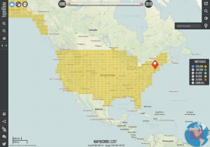
The USGS also offers a national index of digitized historical topographic maps called topoView which allows you to search by location for historical topographic maps and to download the maps in JPEG, KMZ, GeoPDF, and GeoTIFF format. While these maps may not be as printer-friendly as the PDF Quads from National Geographic, the topoView interface provides nationwide access to historical topographic maps at a range of scales. Included below is a quick overview of how to use the topoView interface:

  1. Go to http://ngmdb.usgs.gov/maps/topoview/ and click on Get Maps.topoView_interface
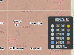
  2. From the topoView browser, search for a location and hit enter. This will zoom the map to area of interest. From the map scales menu (along the right side of the map screen) select the map scale you are interested in viewing or select Show All to see all the scales available. topoView_mapscales
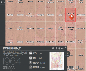
  3. Click on the orange map pin to bring up the map preview and download menu which will appear in the bottom left corner of the map. This will provide the option to download the map in JPEG, KMZ (Google Earth friendly format), GeoPDF, and GeoTIFF formats. If there is more than one map available, just to the right of the preview map will be a link with the number of maps available. In the sample below there are 13 historical maps to choose from for Hartford North, Connecticut.topoView_map_preview

Connecticut Historical Topographic Maps from MAGIC

If you are interested in more topographic maps for Connecticut, MAGIC offers a number of digitized topographic quadrangle maps which can be accessed via MAGIC’s website with a majority of this historic topographic maps available via the topoView application. Included below is a quick outline of how to locate and download topographic maps for areas in Connecticut from MAGIC’s website:

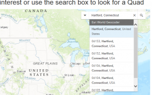
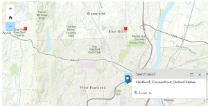
  1. Got to http://magic.lib.uconn.edu/topographic_maps.html and from the interactive Connecticut USGS Topographic Maps Mash-up interface, search for town (ex. Hartford, Connecticut).
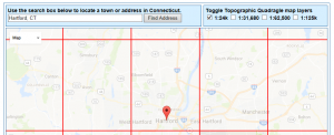
  2. The map will zoom to the area of interest which will show a pin and an outline of the topographic quadrangle(s) nearby. Multiple scales of topographic maps may be available for your area and you can select which scale you want from the Toggle menu along the top right corner of the interactive map interface. More detailed maps will be at 1:24k scale while more general maps will be available at higher scales up to 1:125k.magic_topographic_maps_interface
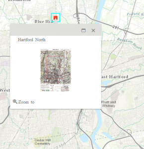
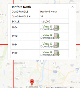
  3. Click the topographic quadrangle outline which covers your area and a pop-up menu will appear. Select the map of interest and click the View and Download link.magic_topographic_maps_interface_popup
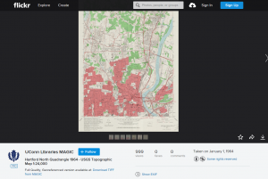
  4. This will take you to MAGIC’s Flickr page where you can download the map as a JPEG (down area in right corner of map view window) or as a full-quality TIFF image (link is located below image). magic_topographic_maps_flickr

Three separate interfaces, each providing access to USGS topographic maps and providing access to current and/or historical quadrangle maps. Enjoy exploring each interface!


WMS Server Outage – 1/27/2016

MAGIC_WMSThe Web Mapping Service (WMS) for the Connecticut State Data Center and MAGIC, a service that provides access to the 1934 aerial photography layer and historical maps for use within GIS applications and is utilized within a number of the interactive map mash-ups for MAGIC will need to be offline part of today (1/27/2016) to resolve connectivity issues with the server. This server experienced an unplanned outage and we are working to resolve this issue ASAP.

During this WMS server update period there may be periods of time when the WMS service could be temporarily unavailable or load times for layers may be impacted.

This maintenance will identify and address additional performance issues with the WMS server and we apologize for the inconvenience any short duration outages of the server may cause.

For users needing access to aerial photography layers via a WMS, the Connecticut Environmental Conditions Online (CT ECO) site offers a WMS with several aerial photography layers which can be accessed at: http://cteco.uconn.edu/map_services.htm

Posted in GIS

Web Mapping Service Maintenance – 12/23/2015

MAGIC_WMSThe Web Mapping Service (WMS) for the Connecticut State Data Center and MAGIC, a service that provides access to the 1934 aerial photography layer and historical maps for use within GIS applications and utilized within a number of the interactive map mash-ups for MAGIC is undergoing maintenance on 12/23/2015. During this maintenance period there may be periods of time when the WMS service could be temporarily unavailable or load times for layers may be impacted.

This maintenance will identify and address performance issues with the WMS server and we apologize for inconvenience any short duration outages of the server may cause.

For users needing access to aerial photography layers via a WMS, the Connecticut Environmental Conditions Online (CT ECO) site offers a WMS with several aerial photography layers which can be accessed at: http://cteco.uconn.edu/map_services.htm


State Data Center Affiliates Training Event

uscensusbureaulogoThe Massachusetts State Data Center at the UMass Donahue Institute is hosting free in-person data training from the U.S. Census Bureau on September 21, 2015 in Hadley, MA.  This event will feature two sections, a morning session focused on the 2012 Economic Census and the OnTheMap data tool for emergency management and the afternoon session will focus on how to use Census data to spur economic development. Participants may attend the morning, afternoon or both but please register using the Evenbrite links below. Seating is limited to 35 attendees per session and the sessions are filling up fast.

Session descriptions

Economic Census and Programs Session – Morning

The morning session (9am-12pm) will start with a general overview of the 2012 Economic Census and Census economic programs in general.  Then there will be a demonstration of Census’s OnTheMap data tool for emergency management.  Your local Census Bureau partner from the New York City regional office will close this session with an overview of the regional office’s activities and other training opportunities they offer.

Register for the Sept 21, 2015 Hadley, MA morning session here: https://www.eventbrite.com/e/us-census-bureau-training-hadley-ma-morning-session-tickets-18444290369

Census Data to Spur Economic Development Session – Afternoon
The afternoon session (1pm-4:30pm) will begin with Census teaching us how to use Census data to spur economic development.  Then Census will show us how to access Longitudinal – Employer Household Dynamics data (LED data), an important new set of data we have been eagerly anticipating.  Your local Census partner will close this session with a demonstration of the Census Reporter web application and an overview of the regional office’s activities and other training opportunities they offer.

Register for the Sept 21, 2015 Hadley, MA afternoon session here: https://www.eventbrite.com/e/us-census-bureau-training-hadley-ma-afternoon-session-tickets-18512106208

Location: UMass Donahue Institute 100 Venture Way #9, Hadley, MA 01035