MAGIC’s WMS services and map mash-ups, including MAGIC 2.0 Online Maps are now back online. We apologize for the unexpected downtime of these services.
Author Archives: Michael Howser
Historical Aeronautical Navigation Maps at MAGIC
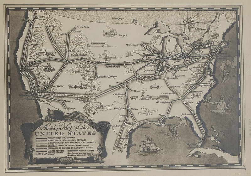
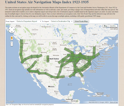
 Today in the United States we can fly coast to coast in a commercial airliner comfortably in less than 6 hours. Air travel has not always been this easy or seamless. Historical air navigation techniques and practices can help us envision the beginnings of air travel and air mail, and really show how drastically aviation navigation technology has evolved in just over 100 years of flight. To help relive and appreciate air navigation from the onset of commercial flight, the University of Connecticut Libraries Map and Geographic Information Center (MAGIC) brings you an interactive index to help users identify flight routes commonly used for passenger and air mail service in the 1920’s and 30’s. Back then there was no such thing as hitting the direct button on your Garmin and following the pink line to your destination!
 |
| Interface for viewing air navigation maps in the MAGIC collection |
NEURISA Day 2012 Call for Presentations – Now Open
- Mobile & Web Technology
- What’s New in GIS / Spatial?
- IT Trends (e.g. virtualization, cloud technology, open source)
- LiDAR
- Abstracts should be less than 300 words.
- Abstract must be submitted by July 2nd, 2012.
- Presentations cannot be product marketing.
- Please submit your presentations online at: www.neurisa.org/neurisaday2012abstract
The New England Chapter of the Urban & Regional Information Systems Association (NEURISA) is a professional organization that provides a forum for: promoting and facilitating the use and integration of spatial information technology, fostering relationships, professional development, and representing the interests of Geographic Information System (GIS) practitioners and Information Technology professionals across the New England region.
URISAis an international association for professionals using GIS and other information technologies to solve challenges in state/provincial, regional and local governments.
Sharing Spatial Data in New England: Policies, Technology, and Trends Webinar
Interested in learning more about policy, technology, and trends in sharing spatial data in New England? NEURISA is offering a free webinar on Tuesday June 5, 2012 from 10:00am-11:30am which will feature 3 presentations on sharing spatial data. Included below is the agenda for this webinar.
Agenda:
Introduction and Overview of Town of Amherst GIS Data Sharing Program – Michael Olkin, Town of Amherst GIS Administrator and NEURISA President
From Public Records to Open Government: Access to Massachusetts Municipal Geographic Data Robert Goodspeed, MIT Department of Urban Studies and Planning.
2011 Storm Season Opens Doors to Data Sharing with Utility Companies Meghan McGaffin, GIS Analyst City of Milford, CT; Editor, CT GeoFocus; Municipal Representative, CT GIS User to User Network.
When: Tuesday June 5, 2012
Time: 10:00am-11:30am
Cost: FREE!
Registration: To register visit: https://www4.gotomeeting.com/register/773331303
A Future Without Key Social and Economic Statistics for the Country?
This past week, the U.S. House of Representatives passed a bill that contains the Census Bureau’s budget. This bill includes several cuts which would impact several datasets including the Economic Census and the American Community Survey (ACS), datasets which provides key economic, population, and housing data critical for planning, analysis and decision making by state and federal agencies, non-profit organizations, private industry, businesses, and researchers.
With the 2010 Census not including a long form, the American Community Survey is THE source for detailed income, poverty, and population data. If the American Community Survey is no longer available, critical datasets for planning, analysis and decision making will no longer available, leaving a great void in data needed for informed decision making in the private and public sectors.
Please take a few moments to review the following link includes a blog post from Dr. Robert Groves, U.S. Census Director, to learn more about how this bill could drastically alter data collection in this country. http://directorsblog.blogs.census.gov/2012/05/11/a-future-without-key-social-and-economic-statistics-for-the-country/
Included below is a brief video from Dr. Robert Groves about the impact this bill could have on data collected by the U.S. Census Bureau.
Connecticut State Data Center Annual Affiliates Meeting – May 11, 2012
The Connecticut State Data Center Annual Affiliates Meeting will be held on May 11, 2012 at the University of Connecticut Storrs Campus and will be include a live stream to enable virtual participation. The meeting will include presenters from state agencies, colleges/universities, organizations, businesses, centers, and more and will provide an opportunity to learn more about data within Connecticut and will encourage collaboration.
This meeting will feature a presentation from Ana Maria Garcia from the U.S. Census Bureau on the American Community Survey and the afternoon will feature a series of hands-on workshops related to data usage and mapping.
This meeting is open to the public and please share this announcement with anyone that would be interested in attending.
Details for the Connecticut State Data Center Annual Affiliates Meeting are included below
Date: Friday May 11, 2012
Time: 10:00am-4:00pm
Location: University of Connecticut Thomas J. Dodd Research Center – Storrs Campus
Cost: Free!
Who should attend?: Anyone is welcome to attend this meeting
Registration: Click Here to Register for In-person or for the Live Webcast
For more details on this event visit: http://ctsdc.uconn.edu/affiliates/
NEARC Spring Meeting – May 22, 2012
The Northeast Arc Users Group Spring Meeting will be held on Tuesday May 22, 2012 from 8:00am-5:00pm at Smith College in Northampton, MA. This meeting will feature multiple presentations on GIS, Spatial Analysis, Data Sharing, Census Data, and more and includes lunch for all participants!
Register soon to for the early bird discount. To register visit: http://www.cvent.com/d/lcqpjb/4W
For additional details on the schedule for the NEARC spring Meeting visit: http://www3.amherst.edu/~aanderson/nearc/schedule2012.html
This is a great meeting and if you are interested in learning more about GIS and geospatial technology plan to attend! This meeting is a great networking opportunity and we hope to see you there!
2011 Annual Survey of State Government Tax Collections – Now Available
The 2011 Annual Survey of State Government has been released by the U.S. Census Bureau which indicates that overall tax collections for states increased $55.7 billion to $757.2 billion in fiscal year 2011, up 9.8%. General sales tax revenue was at $234.5 billion in fiscal year 2011, up 5.4%.
State Government Tax Collections 2011: Connecticut
Within the state of Connecticut, the 2011 Annual Survey of State Government indicates that State Government Tax Collections for Fiscal Year 2011 totaled $13,432,252,000. The following table includes a brief breakdown of the State Government Tax Collections for fiscal year 2011 for Connecticut:
|
State Government Tax Collections: 2011
|
||
|
(Amounts in thousands)
|
||
|
Item
|
Connecticut
|
|
|
Total taxes
|
13,432,252
|
|
|
Property taxes
|
X
|
|
|
Sales and gross receipts
|
5,522,780
|
|
|
General sales and gross receipts
|
3,252,123
|
|
|
Selective sales taxes
|
2,270,657
|
|
|
Alcoholic beverages
|
48,923
|
|
|
Amusements
|
409,188
|
|
|
Insurance premiums
|
195,968
|
|
|
Motor fuels
|
477,772
|
|
|
Pari-mutuels
|
7,220
|
|
|
Public utilities
|
274,640
|
|
|
Tobacco products
|
400,562
|
|
|
Other selective sales
|
456,384
|
|
|
Licenses
|
446,755
|
|
|
Alcoholic beverages
|
12,441
|
|
|
Amusements
|
128
|
|
|
Corporation
|
27,810
|
|
|
Hunting and fishing
|
5,565
|
|
|
Motor vehicle
|
195,286
|
|
|
Motor vehicle operators
|
38,664
|
|
|
Public utility
|
704
|
|
|
Occupation and business, NEC
|
161,062
|
|
|
Other licenses
|
5,095
|
|
|
Income taxes
|
7,142,062
|
|
|
Individual income
|
6,469,246
|
|
|
Corporation net income
|
672,816
|
|
|
Other taxes
|
320,655
|
|
|
Death and gift
|
227,237
|
|
|
Documentary and stock transfer
|
93,358
|
|
|
Severance
|
60
|
|
|
Other
|
0
|
To view (and download) this data and related information on the 2011 Annual Survey of State Government Tax Collections survey visit: http://www.census.gov/statetax
Treworgy Planetarium Event Global Astronomy Event 2012 – Canceled
Due to the rain being forecasted for April 21, 2012 the Treworgy Planetarium at Mystic Seaport Global Astronomy event from 8:00pm-midnight has been canceled.
We apologize for this inconvenience and be sure to check the Treworgy Planetarium website for future events


