Month in Review – CtSDC at MAGIC – June 2012

Month in Review – CtSDC & MAGIC – June 2012
To provide our readers with a summary of usage trends, the Connecticut State Data Center (CtSDC) and the University of Connecticut Libraries Map and Geographic Information Center (MAGIC) will be publishing a summary report for each month to this blog. This summary report provides our readers with an opportunity to view trends in usage of webpages, examine trends in keyword searches, and will feature a brief overview of projects in development. Included below are highlights from June 2012 which focuses on five main areas: User Inquiries, Web Content Views, Trends in Webpage Usage, Trends in Keywords, and Projects in Progress.
I. User Inquiries
Total User Inquiries
Included below are the statistics for user inquiries received by phone, email, and in-person during June 2012. As the data clearly visualizes, the number of inquiries continues to rise with the year to date totals representing a 109% increase when compared to the January 1- June 30 of the previous year.
Web Resource
Total Inquiries
Monthly Change
vs. 2011
YTD Inquiries
for 2012
YTD Change
vs. 2011
Connecticut State Data Center
161
35%
835
88%
MAGIC
128
83%
849
136%
Total
289
53%
1,684
109%


II. Web Content Views
Total Unique Content Views
Included below are the web content unique views statistics for June 2012 which include comparisons with June 2011, the year to date (YTD) unique views and the change in the total number of unique views when compared to the same time period (January 1 – June 30)  from the previous year.
Web Resource
Unique Views
Monthly Change
vs. 2011
YTD Unique Views
for 2012
YTD Change
vs. 2011
Connecticut State Data Center
1,951
21%
9,492
12%
MAGIC 2.0 Online Maps
410
-53%
3,284
-49%
MAGIC  Flickr Collections
35,066
77%
200,313
46%
MAGIC News Blog (Retired)
35
75%
221
16%
MAGIC Website
10,622
21%
75,130
10%
Outside the Neatline Blog
953
59%
5,251
49%

Total
49,038
55%
293,705
31%
Total Content Views
With more users viewing web content more than once from MAGIC and the Connecticut State Data Center, the total views of web content provides a more detailed view of the trends in usage. The following table includes the usage trends for the total number of views, monthly change when compared to same month in 2011, the year to date (YTD) total number of views and the change in total views when compared to the same time period (January 1 – June 30) from the previous year.
Web Resource
Total Views
Monthly Change
vs. 2011
YTD Total Views
for 2012
YTD Change
vs. 2011
Connecticut State Data Center
2, 716
9%
14,136
10%
MAGIC 2.0 Online Maps
3,044
-62%
28,738
-56%
MAGIC  Flickr Collections
35,066
77%
200,313
46%
MAGIC News Blog (Retired)
55
175%
310
36%
MAGIC Website
16,474
21%
118,827
12%
Outside the Neatline Blog
1,288
61%
7,129
45%
Total
58,644
31%
369,467
13%
III. Trends in Webpage Usage – June 2012
Ever wondered what the most popular pages are at MAGIC and the Connecticut State Data Center? Included below are the top 5 most popular pages for June 2012.
Most Popular pages – Connecticut State Data Center
Page
Total Views
916
579
397
132
124
Most Popular pages – MAGIC 
Page
Total Views
3,362
  2,865
1,105
911
773
Most Popular pages – Outside the Neatline Blog – June 2012
Page
Total Views
166
     71
65
61
43

IV. Trends in Keywords – June 2012
At the Connecticut State Data Center and MAGIC each month we analyze keyword searches conducted on our websites to determine areas to focus increasing accessing to maps, data, and resources. Keyword provide us with an opportunity to see trends, areas for improvement, and have been integral to providing guidance on website development and improvements. Included below are keyword trends for June 2012.

Most Frequent Keywords – Connecticut State Data Center
Keyword
Demographic Profile Senate
Family statistics
06050
1940 Census Data West Hartford
  
Most Frequent Keywords – MAGIC
Keyword
Campus map
parcels
Appalachian trail
Canaan
Elevation

V. Projects in Progress – June 2012
Each month the students and staff at MAGIC and the Connecticut State Data Center are working on a series of projects, tasks, data sets, and resources which users typically don’t know about until we add the resource to our website. Included below is a list of projects that are currently underway which will be completed in the coming months and made available in their final forms via our websites.

  • Connecticut Population Projections 2015-2025 – This project involves developing updated population projections based on the 2010 Census, Birth and Mortality data from the Connecticut Department of Public Health, and developing derived migration based on these data for multiple levels of geography. This project is still underway and the public is able to view a preliminary version (population estimates are subject to change as we refine the methods over the next month). View the preliminary projections and the interactive data interface at: http://ctsdc.uconn.edu/projections.html
  • Air Navigation Maps 1923-1935 Index – This project, developed by Trevor Rzucidlo during his internship and independent study at MAGIC during Fall 2011-Spring 2012, provides an interactive index to a series of over 150 historical air navigation maps from 1923-1935 for the United States. The index is currently available and additional georeferenced maps are being added in the coming weeks. The interface provides users with quick access to individual maps and is based on Google Fusion Tables. Check out this index at: http://magic.lib.uconn.edu/mash_up/air_navigation_index.html
  • Aerial Photography TIFFs and PDFs Project – In the coming months users will be able to access full-quality TIFF, GeoTIFF, and PDF images for aerial photography from 2004, 2006, 2008, 2009, and 2010 via a series of interactive indexes based on Google Fusion Tables. Once completed, users will be able to download TIFF, GeoTIFF, and PDF images for a location directly from the interactive aerial photography index.
Have an idea for a project or suggestions for improvements to MAGIC and the Connecticut State Data Center’s website and web offerings? Leave us a comment or contact us at magic@uconn.edu.  


Each month we will be posting a “Month in Review” article so check back in a month to see the latest information on usage trends at MAGIC and the Connecticut State Data Center.

Is it a Map or a Chart?

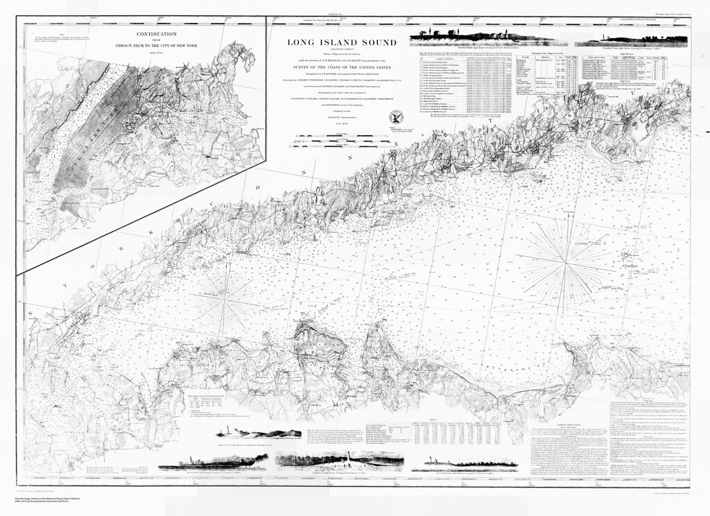
Long Island Sound (western sheet) / from a trigonometrical survey under the direction of F.R. Hassler and A.D. Bache

I’m starting a new adventure and it all came about from playing around with maps!  Last month I was hired as the supervisor of the Treworgy Planetarium at Mystic Seaport and that means you’ll probably be hearing less and less from me as an author here at Outside the Neatline.  You may be hearing about special events or items of interest that I stumble across or new geographical information related to the maritime tradition.  For example, do you know what the difference between a map and a chart?  I’ve had to learn quickly!

Part of a chart, showing Kidds Humbug, Lents Cove From the Mystic Seaport Image Archives

Reading and using a chart is one of the basic skills that are taught at the Treworgy Planetarium.  Concepts such as map projections, scale, taking bearings and plotting headings are covered in the classwork (very geographical).  Other course offerings include taking a noon sighting of the sun with a sextant, celestial navigation to find latitude and longitude, and marine weather.

In the next few months I’ll be developing a new blog platform for the Treworgy Planetarium so keep your eyes peeled!

MAGIC and Connecticut State Data Center Workshops – Fall Semester

Included below is a listing of upcoming workshops offered by the University of Connecticut Libraries Map and Geographic Information Center (MAGIC) and the Connecticut State Data Center for Fall Semester 2011. All of these workshops are free and open to the public. Links to register for each workshop are included below:

Georeferencing Maps – Basics
Do you have scanned or digitized maps you would like to incorporate within your research using ArcGIS or other mapping software? This workshop will provide an overview of how to take a scanned map and append geographic coordinates, a process known as georeferencing, which will enable you to create customized maps.
Day Date Time Location Max
Enrollment
Register
Friday 11/11/11 1:00 PM to 2:00 PM Babbidge Library Undergraduate Research Classroom 20 Register

Locating Census 2010 Data using the NEW American FactFinder
The U.S. Census Bureau has introduced a NEW American FactFinder online Census data tool with enhanced searching and data display capabilities in conjunction with the release of 2010 Census data.  In this workshop you will learn how to use the new American FactFinder to locate and download data  – and create thematic maps – from a wide variety of population, economic, and housing information in the 2010 and 2000 decennial Censuses. From information on individual neighborhoods or zip codes, to state- or national-level data, the new American FactFinder is a powerful tool for navigating the vast amounts of data made available by the U.S. Census Bureau. The new American FactFinder will also soon replace the legacy American FactFinder as the platform for retrieving data from the American Community Survey (the ongoing Census program which produces data on educational attainment, income, occupation, marital status, and other detailed social and economic characteristics), and will also deliver data from the Economic Census. Join us to learn more about how to effectively navigate the NEW American FactFinder.
Day Date Time Location Max
Enrollment
Register
Wednesday 11/30/11 10:00 AM to 11:30 AM Babbidge Library Level 2 Electronic Classroom 18 Register


Making Maps Online with ArcGIS.com

Want to create a map and share it with colleagues or a class? This hands-on workshop will provide participants with an opportunity to learn how to create maps using ArcGIS.com which can integrate data from multiple sources, be viewed on mobile devices, and create a series of maps to highlight areas of interest for projects and/or your own research.
Day Date Time Location Max
Enrollment
Register
Monday 10/24/11 2:00 PM to 3:00 PM Babbidge Library Level 1 Electronic Classroom 20 Register
Wednesday 10/26/11 10:00 AM to 11:00 AM Babbidge Library Level 1 Electronic Classroom 20 Register

Geography Awareness Week Kickoff Event – November 3, 2011 @ UConn

Geography: The Adventures in Your Community
Thursday, November 3, 2011 4:45-8:00pm
Thomas J Dodd Research Center at UConn
Storrs, Connecticut
The heart of this year’s theme will revolve around a series of topics that encourage individuals or teams of students, families, or friends to explore their own communities through geographic eyes, and challenge them to look at things from a geographic perspective.
Program Agenda
4:00-4:30 Pre-conference tour of UConn Libraries – MAGIC
4:30-4:45 Registration – Thomas J. Dodd Research Center
4:45-5:00 Welcome – Bill DeGrazia & Tom Brodnitzki, CGA Co-Coordinators
5:00-6:00 Keynote Speaker – Arthur Bakis – U.S. Census Bureau Boston Regional Office
6:05-6:55 Buffet Dinner and Remarks
7:00-7:50 Breakout Sessions
I – Elementary Teachers – Allyson Lubs, Professional Development CGA
II – Middle & High School Teachers – Kristie Blanchard, NE Geography Teacher of the Year
III – Exploration of American Community Survey (ACS) –
Michael Howser, Connecticut State Data Center
7:50-8:00 CEU Records and Drawings

Participation Fee: $25 (add $10 if you would like to be awarded .3 CEUs upon completion of the program). The fee includes registration and a light dinner. Checks should be made payable to “Connecticut Geographic Alliance.
Pre-Service Teachers receive a reduced registration fee of $10 and currently enrolled UConn Students receive free admission.
This workshop is a collaboration of the Connecticut Geographic Alliance, University of Connecticut Department of Geography, University of Connecticut Libraries Map and Geographic Information Center (MAGIC), and the Connecticut State Data Center.
To register for this event download the Registration form.

Converting JP2000, JP2 files to other formats

There is a host of good reasons why archives like to preserve their images as JP2000 or JP2 files.  The two biggest reasons are the compression saves a large amount of space and the visual quality is excellent after the compression takes place.


What is a JP2000?

The downside to these file formats (depending on who you are) is that they are not very accessible in terms of software that can view or edit.  This is especially true if you are a dedicated user of non-apple personal computers.

So what do you do when you find an amazing map on the Library of Congress site that you download as a JP2000?  Not much, unless you find some third party software that can handle this file type and convert it into a much more accessible format.  This is where the Freeware IrfanView steps up and helps us all out.


Library of Congress Map Collection Site

IrfanView is a free image viewer that allows for light editing of images as well as converting file formats.  If you do use IrfanView be sure to download the optional plugins so that you can convert your JP2000 files to something more useful to you.

1. After loading a JP2 or JP2000 file you can see the basic and clean layout of the image viewer.

2. To convert the file simply navigate to the File drop-down menu and choose Save as… Note the many file types available and options within each file type.

3. That’s it!  You’ll also notice a batch conversion option in the File menu which will perform the same operation with a few more options.  It’s also helpful if you have a large amount of images you’d like to convert!
Indeed there are a host of viewing software packages available, so if this platform does not suit your taste I’m sure you will find others!  I have had good experience with this platform because its lightweight, converts files with ease, and the batching feature is a must with large digital image collections (really helpful when you work at a Map and Geographic Information Center).  So at the very least give it a try when Photoshop won’t read your JP2000 file to get you out of a jam.  
Cross posted MT and G

MAGIC’s “How Do I…” Page Has New Look

MAGIC’s How Do I… page now features videos.

As of late, we have been highlighting the new organization and added capabilities of MAGIC’s website (See this post about the GIS Data Page and this post about Aerial Photography in Connecticut). MAGIC’s How Do I… page has become the latest update. This page now includes tutorials for both ArcGIS and Google products – videos included! Visit it for more!

Outside the Neatline Enters its 3rd Year

Happy 2nd Birthday to Outside the Neatline! What began as a side project by graduate students in the UConn Department of Geography and MAGIC, has blossomed into a dependable resource for geospatial news, historical maps, tech tips and more for the UConn community and beyond. A special thanks all of our contributors, past and present, for the blog’s continued success. Also, thanks to our readers. We hope you will continue to enjoy our content!
To commemorate this occasion, here are some of our top posts.
Top 10 Posts by Traffic:
Here are some of the MAGIC Staff and Outside the Neatline Contributors’ Picks:

Aerial Photography of Connecticut

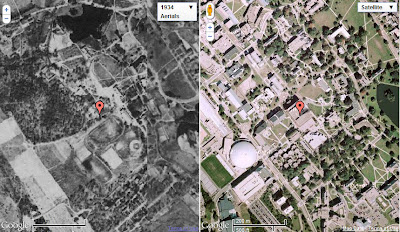
On the left, UConn (Storrs Campus) in 1934; on the right UConn (Storrs Campus) present-day.

A recent blog post highlighted the new GIS Data Distribution Page on MAGIC’s website. In addition to the new look on this page, the Aerial Photography Page has been updated as well! Now, when you visit this page, you will find aerial photography of Connecticut from the following sources:

  • Connecticut Ecological Conditions Online (CT ECO) Aerial Photography Viewer
  • Connecticut Historical Aerial Imagery from MAGIC
  • Connecticut Historical Aerial Photography from the Connecticut State Library
  • Connecticut Historical Aerial Photography Mosaic Map Mash-Ups from MAGIC
A Screenshot from MAGIC’s CT Aerial Photography Mosaics Mash-Ups. The red marker indicates our location, Homer Babbidge Library. On the left, imagery from 1934, and to the right, Google’s current imagery.
The Connecticut Aerial Photography Mosaic Mash-Ups enable you to view, pan and zoom linked historical (1934, 1991, 2006, or 2008) and and contemporary imagery…check it out!