MAGIC GeoCommons Enhancements!

We are delighted to announce that the University of Connecticut Libraries Map and Geographic Information Center – MAGIC GeoCommons space has been upgraded thanks to support from the University of Connecticut Libraries Planning Team. The MAGIC GeoCommons space is a publicly accessible space designed to enable students to collaborate on location based research. This upgraded space includes 2 collaborative tables where small groups can collaborate using their laptops (or using the desktop computer available at one of these tables) and display their work on a 46″ screen. To further promote collaboration, 5 smaller tables on wheels are available in the space and can be reconfigured to allow for small to large groups that need to collaborate with using print materials (e.g. atlases, books, and maps) and laptops.

Now that finals are approaching, be sure to stop by and visit the new MAGIC GeoCommons space if you are on campus!

Want to preview the space virtually? Included below are photos of the MAGIC GeoCommons space before and after the enhancements were added to the space:

Before
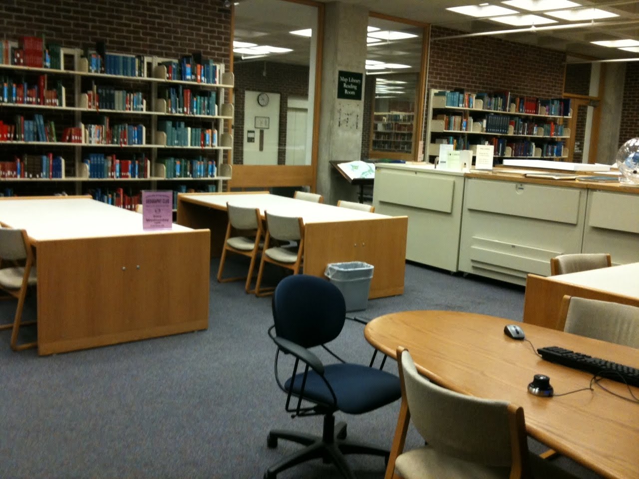
GeoCommons featured 3 large tables, 15 chairs, and a large screen for collaborative use

After
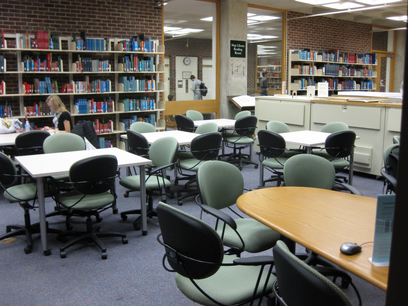
GeoCommons now features 5 tables on wheels, 2 collaborative tables, 2 – 46″ screens with laptop connectivity, and 30 new chairs on wheels!

University of Connecticut Geography Club

A new and forming group of students in the Department of Geography at the University of Connecticut is forming a geography club for undergraduate students.  The club typically meets on Wednesday evenings at 7:00 PM in CLAS room number 420.  The next meeting dates are:

Wednesday November 17, 2010 at 7 PM
Wednesday December 1, 2010 at 7 PM

Free pizza will be provided to all who attend on December 1st.  Preliminary activities that the club is considering engaging in are:

Your involvement in the club will present opportunities for leadership development, social networking, and opportunities for degree related experience.  Come check out the geography club at UConn!

LibQUAL+ Survey – Help the Libraries Help You And You May Win $500!

Attention all UConn Students, Faculty and Staff!

The University of Connecticut Libraries needs your help and participation in the Fall 2010 LibQUAL+TM Survey.

The LibQual+TM Survey has been used by more than 1,200 libraries internationally to periodically and consistently track, understand, and act upon their users’ opinions of library service quality.

As in the past, the LibQual+TM Survey results will inform our Libraries’ planning on how to best provide library services to the UConn community. This survey process has been reviewed by UConn’s Institutional Review Board (IRB) and all responses are confidential and will not be associated with a respondent’s e-mail address or other personal information.

One participating student* (grad or undergrad) will win a $500 GIFT CARD from the UConn Co-op!

The link to the survey can be found in your e-mail. If you missed the e-mail, have questions, or need assistance in any way, please contact librarysurveys@uconn.edu

Please complete the survey by: December 10, 2010

Thanks for participating!

* Participation in the drawing is optional. Eligible students must be registered to take classes at the University of Connecticut during the Fall, 2010 semester; have completed no more than one online survey; have entered an optional “uconn.edu” e-mail address at the time the online survey form is completed; not be an employee of the State of Connecticut, including student employees of the University, or of the UConn Co-op; permit the University of Connecticut to make public a photograph, name, home town, academic year and major of the winning entrant; agree to any rules and restrictions placed upon the use of the gift certificate by the UConn Co-op.

NESTVAL Geobowl Champions

Congratulations to the University of Connecticut Department of Geography NESTVAL Geobowl team!
Last Friday on October 29th, Adam Pokusa, Anthony Erstad, Jeff Dunn, Naomi Lazarus, and team captain Brandon Cramer faced 5 other teams representing: University of New HampshireSouthern Connecticut State UniversityCentral Connecticut State UniversityKeene State College, and Salem State University.
Left to Right: Adam Pokusa, Anthony Erstad, Jeff Dunn, Naomi Lazarus, and Brandon Cramer.
Team Captain Brandon Cramer accepts the 2010 NESTVAL Geobowl trophy.

Did You Know #32 Google 2010 US Election Ratings


Want to know where the most contentious US House, US Senate, and Governors races are this November? Check out Google’s 2010 US Election Rations map mash-up which includes data from CQ Politics, Rothenberg Political Report, and other sources with a daily to weekly update. With this tool you can look at national and state level polling trends. Check out this Interactive Map!

New Maps added to CT ECO!

Are you looking for maps of Connecticut geology, water resources (hydrography), or topography maps which can be viewed online for use in your research or in the classroom? Check out the Connecticut Ecological Conditions Online (CT ECO) website which has just added the following maps in high-quality PDF format to the CT ECO Map Catalog:

Town maps:
Contour Map
Q3 Flood Zone Map
State maps previously published by DEP, USGS and CT Geological and Natural History Survey:
Bedrock Geological Map of Connecticut
Bedrock Mines and Quarries of Connecticut
Ground-Water Availability in Connecticut
Ground-Water Yields for Selected Stratified Drift Areas in Connecticut
Natural Drainage Basins in Connecticut
Planimetric Map of Connecticut
Quanternary Geologic Map of Connecticut and Long Island Sound Basin (Glacial Geology)
Radar Image Map of Connecticut
Sand and Gravel Resources of Connecticut
Shaded Relief Map of Connecticut
Surficial Aquifer Potential Map of Connecticut
Surficial Materials of Connecticut
Topographic and Woodland Map of Connecticut
Topographic Map of Connecticut
CT ECO also provides online map viewers which feature aerial photography, roads, town boundaries and other features which can be added to ArcGIS (a popular GIS software) . To learn more about CT ECO visit: http://cteco.uconn.edu/index.htm

Opportunities #6 – Mapping the Transition from Colony to Nation @ Chicago’s Newberry Library

The Newberry Library in Chicago Illinois is hosting the 17th Kenneth Nebenzahl, Jr., Lectures in the History of Cartography on “Mapping the Transition from Colony to Nation” November 4-6, 2010. This multi-day lecture series will feature eight scholars, who will examine how peoples and states around the world emerging from colonial status used maps to define, defend, and administer their national territories, to develop their national identities, and to establish their place in the community of nations.

The lectures series, beginning on Thursday evening, November 4, 2010, and running through Saturday morning, November 6 will feature Raymond Craib (History, Cornell University), Magali Carrera (Art History, University of Massachusetts-Dartmouth), Jordana Dym (History, Skidmore College), Lina del Castillo (History, Iowa State University), Tom Bassett (Geography, University of Illinois at Urbana-Champaign), Jamie McGowan (Geography, University of Illinois at Urbana-Champaign), Sumathi Ramaswamy (History, Duke University), and Karen Culcasi (Geography, West Virginia University). A full program schedule is available on The Newberry Library’s website at http://www.newberry.org/smith/nebenzahl/neb17.html.

The Nebenzahl Lectures are free! They do require that all persons wishing to attend make a reservation. For reservations and further information please contact the Hermon Dunlap Smith Center for the History of Cartography, 60 W. Walton Street, Chicago, IL 60610 USA; e-mail smithctr@newberry.org ; phone 312-255-3659.

This announcement was brought to our attention via the Maps-L listserv.

Khan Academy

While this isn’t geography specific, I think it’s an important resource to mention for those interested in online resources for education. Khan Academy was recently reviewed on CNN’s Money website citing Bill Gates praise for the innovative website.

Topics covered on the website are vast and include a wide variety of Mathematics, Science, and even some Social Science. Watch the video embedded below from PBS NewsHour to get an overview of how Sal Khan has leveraged the power of online education resources!

Geospatial Training Opportunities from UConn’s CLEAR

Are you looking for an opportunity to learn more about geospatial technologies? If so then be sure to check out the late summer/fall 2010 geospatial training courses offered from our colleagues at UCONN’s Center for Land use Education and Research (CLEAR).

Geospatial Technologies at Work: An Introduction to GIS August 31-September 2

An intensive three-day course that introduces students to basic GIS concepts through the use of ESRI’s desktop GIS software. Course fee $300

Pictures, Points and Places: An Introduction to GPS September 16-17

A two-day hands on course that covers a wide variety of topics from planning data collection activities to the incorporation of GPS data into geographic information systems and “earth viewers” such as Google Earth. Participants will also learn how to integrate and georeference digital photographs in their mapping projects. Course fee $150

Mashup Madness: Using Google Tools to Create Maps on the Web October 19

NEW COURSE! This one-day course introduces students to the basics of creating simple mapping “mashups” – interactive, online maps using free tools including Google Maps and Google Earth. Topics explored include Google Maps “My Maps” and creating KML in Google Earth as well as techniques for sharing online maps through email and embedded content. Course fee $100

Creating and Using Geospatial Models: An Introduction to ModelBuilder for ArcGIS November 23

A one-day course that introduces ArcGIS users to the capabilities and uses of ModelBuilder, a tool which allows users to create geoprocessing models to automate repetitive tasks within ArcGIS. Some working knowledge of ArcGIS is strongly recommended. Course fee $100

Developing Custom Geoprocessing Tools: An Introduction to Python Scripting December 8-9

A two-day course which introduces ArcGIS users to the basics of writing and integrating Python scripts in ArcGIS. Python is a scripting language supported by ESRI. This course aims to provide students with the foundation and resources necessary to develop proficiency with automating geoprocessing tasks with Python scripts. This is an advanced course, individuals should be familiar with ArcGIS, ArcToolbox and geoprocessing tools. Course fee $150

* Note: All GIS training courses are currently taught using ArcGIS 9.3. ArcGIS 10 courses will begin in early 2011.

For more information about course content and registration, please visit: http://clear.uconn.edu/geospatial.